Rain & storms build in late this evening, new severe risk for Sunday
Gear up for a cool, gloomy and soggy next couple of days. New as of today, there is now a severe weather threat for Easter Sunday.
Flood Watches go into effect this evening for southern counties and will continue until Sunday evening. Over the course of the next 3 days, we all see the potential for widespread 1″ to 2″ with higher amounts possible south of I-70 (possible for 3″ to 4″).
TODAY: Temperatures remain in the 50s, with cloudy skies and spotty chances for rain. As we get into the evening, a First Warn is in place for strong to severe storm potential for those along and east of I-35.
Isolated to widely scattered strong to severe storms are possible late this evening and into the night. Any strong to severe storm gets going will bring the potential for damaging winds, hail and heavy rainfall.
Spotty rain and storm activity will build in from the southwest along and east of I-35 likely after 5 pm. We should see scattered activity build for those along and south of I-70 into the overnight.
SATURDAY: The cool and gloomy conditions are expected once again with high temperatures only in the mid to upper 50s. At this time, the morning looks to be mainly dry. Rain will build into the afternoon and evening and generally be scattered (off & on). Winds will be between 5 to 15 mph with gusts to 20 mph.
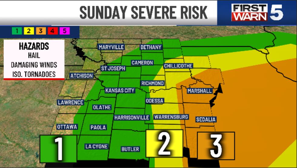
SUNDAY: A First Warn is in place for Sunday. Sunday will be a day we need to watch very closely, as two scenarios will be possible. As mentioned above, there is the threat of severe weather in the afternoon and evening. A level 1/5 risk for severe weather for the metro, level 2/5 risk Chillicothe south to Warrensburg. A level 3/5 risk for severe weather for our eastern counties including Sedalia and Carrolton.
Widespread rain is expected for the morning. However, we could see two scenarios by the afternoon. Scenario 1 is when we see widespread rain throughout the day. That would mean it would be more difficult for strong to severe storms to form. However Scenario 2, would bring widespread rain in the morning, leading to breaks and dry time in the afternoon. These breaks would allow for more mixing of the atmosphere and therefore “better” potential for severe storms. We will continue to to watch Sunday VERY closely and continue to give you that latest information when we know it.
High temperatures remain cool for Easter Sunday and only reach the mid to upper 50s.
If you are thinking about Easter Egg Hunts, inside may be best for this weekend. While there will be dry times over the weekend, the ground is expected to be pretty soggy, wet and muddy.
FINALLY - Monday brings sunshine back to the area! High temperatures rise back into the 70s. The 70s are expected well into next week but we are seeing signs of another batch of active weather mid week.

To get the latest weather updates sent to your phone, the KCTV5 Weather app here.
Copyright 2025 KCTV. All rights reserved.


