First Warn Forecast: The first 80s of the year with breezy to windy conditions
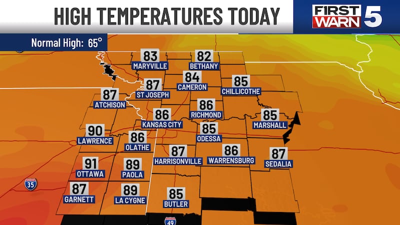
KANSAS CITY, Mo. (KCTV) - Gear up for our warmest day of the year so far! While we will be toasty, keep in mind it will be a breezy to windy day.
High temperatures hit the mid to upper 80s for most but a few 90s will be possible. We will be breezy to windy, winds will get stronger as you head south. The metro will likely see winds sustained between 15-20 mph with gusts to 30 to 35 mph. A Wind Advisory is in effect for our southern counties until 4 pm for sustained winds of 20 to 35 mph and gusts to 45 mph, isolated gusts of 50 possible.
Despite the clouds today, the UV index still remains high so make sure to keep the SPF handy if you plan to spend time outside. Have fun and of course stay cool & hydrated because we are not used to these temperatures yet.
The hot conditions with highs in the 80/90s will be short lived as a cold front drop through the region this afternoon and evening - resulting in a 20+ degree cool down for our Monday.
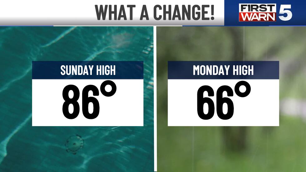
Monday will be significantly cooler, high temperatures will only reach the mid 60s. Skies will be mostly to partly cloudy with the 20% chance for some rain showers. Rain shower chances are manly in the mornign between 7 AM to 1 pm for those along and north of I-70. A few more showers and isolated thunderstorms will be possible - come the evening in the northeastern counties.
The rest of next week brings roller coaster temperatures and several spotty chances for rain and thunderstorms. We stay dry Tuesday with temperature sin the mid 60s. We warm up Wednesday to the low 70s and spotty showers are possible. Thursday, we soar into the low 80s with 30% chance for rain and storms. Our northern counties have the chance for strong to severe storm activity, we will continue to monitor this over the coming days. Friday, we cool off to the low 70s. Next weekend looks to bring a more active weather pattern and temperatures remain seasonal in the mid 60s.
Copyright 2025 KCTV. All rights reserved.


